Masterplan submission for Strategic Growth Site 10: North of South Woodham Ferrers

South Woodham Ferrers Town Council Response to Stage 2 Masterplan Consultation for Site 10
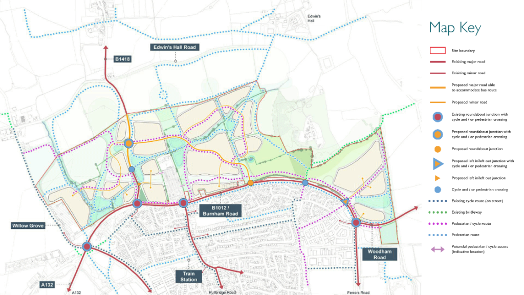
Road Infrastructure The Town Council finds the plan lacking in a cohesive road transport plan that takes into account all the factors that are likely to cause ingress and egress traffic congestion through the Local Plan time period until 2036. The Masterplan is far too centred and focused on traffic getting in and out of the individual building site sectors within the new development site 10 rather than presenting an integrated view that is sustainable to this increasingly congested area of Essex. Lack of consultation with neighbouring Councils to the South of Chelmsford regarding this Masterplan also demonstrates apathy in the modelling scenarios that were used as evidence for the Local Plan.
Road Infrastructure Conclusion All of these changes coming and proposed, directly create a disproportionality higher peak congestion flow for the residents of South Woodham Ferrers Residents using the road system and as such, until the modelling is complete and proven and a satisfactory road infrastructure is proposed, the Town Council cannot support the Masterplan for Site 10.
Introduction
Land to the north of South Woodham Ferrers is allocated for development in the adopted Chelmsford Local Plan, within which it is referred to as Strategic Growth Site (SGS) 10 (known from here on as ‘the site’).
The Local Plan policy requires a Masterplan to be prepared to guide the future development of the site. Chelmsford City Council has adopted a procedure for preparing masterplans.
This document forms the ‘Stage 3’ masterplan, submitted for formal consideration by Chelmsford City Council. This masterplan has been updated following extensive engagement (‘Stage 0’) and technical stakeholder workshops (‘Stage 1’). It also incorporates further updates following public consultation (‘Stage 2’).
This document has been prepared jointly by Broadway Malyan and David Lock Associates on behalf of Countryside Properties (CP), Bellway and Essex County Council (ECC).
The Local Plan policy for the site requires it to achieve:
• Around 1,000 new homes of mixed size and type to include affordable housing
• Travelling Showpeople site for 5 serviced plots
• 1,000 sqm of business floorspace
• 1,900 sqm of convenience retail floorspace
• Potential co-location of a new primary school with an early years and childcare nursery (min 2.1 hectares) and one stand-alone early years and childcare nursery (circa 0.13ha); or two new stand-alone early years and childcare nurseries (circa 0.13 ha each)
• Neighbourhood Centre incorporating provision for convenience food retail (1,900sqm), flexible neighbourhood scale business (1,000sqm) and community and healthcare provision
• Integration of flexible workspace facilities
• Development maximising sustainable travel opportunities
• Main vehicular access to the western and central parcels will be from the B1418 with potential for additional access from Burnham Road subject to traffic management measures being agreed by the Local Highway Authority
• Provide new public transport routes / services
• Provide an effective movement strategy within the site
• Provide new and enhanced cycle routes, footpaths, Public Rights of Way and bridleways where appropriate
• Provide additional and / or improved pedestrian and cycle connections to the Town Centre and railway station
• Provide high quality circular routes or connections to the wider Public Rights of Way network located away from the Crouch Estuary
• Provide a dedicated car club for residents and businesses on site and available to the rest of South Woodham Ferrers
• An appropriate landscaped setting for development consisting of suitably dense planting belts and natural buffers to development edges and Local Wildlife Sites
• Provide areas for natural SUDS and flood risk management
• Capacity improvements to the A132 between Rettendon Turnpike and South Woodham Ferrers, including necessary junction improvements
• Multi-user crossings of the B1012 in South Woodham Ferrers which may include a bridge or underpass
• Details of other infrastructure requirements not set out in the policy such as secondary education will be addressed through S106 and CIL.
The site
The site (outlined in red on the opposite page) covers an area of 121.28 ha and is located to the north of the town of South Woodham Ferrers. It stretches from Willow Grove in the west to land around Bushy Hill in the east. The southern edge is largely formed by Burnham Road. The B1418 runs up through the site and northwards towards the settlement of Woodham Ferrers.
The site largely composes agricultural fields and the majority of the western half of the site is relatively flat with the land form rising to the north, beyond the site boundary. The eastern part of the site lies on gently sloping land, again, rising towards the north.
A detailed description of the site and its features is contained later in this report.
‘Land North of South Woodham Ferrers: Stage Three Masterplan Framework Sumbmission’, Chelmsford City Council, January 2021, Page 6, https://www.chelmsford.gov.uk/, (accessed 17 September 2021)